Throughout July, smoke from wildfires in Canada and the US West Coast significantly impacted irradiance across North America, while Hurricane Beryl and upper atmospheric conditions delivered unstable cloud cover across the central and eastern United States.
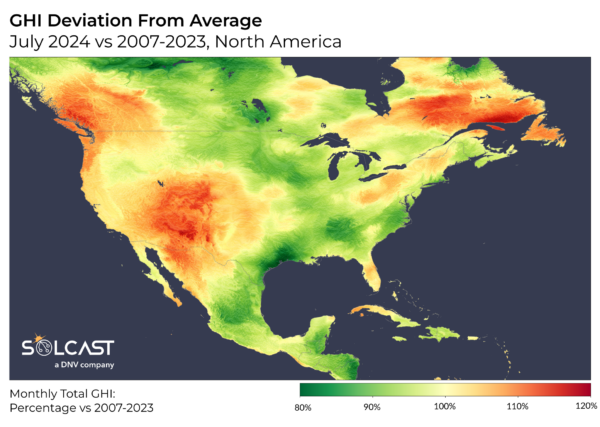
Analysis using the Solcast API shows that the combined effects of reduced clearsky irradiance from smoke-related aerosols and cloud cover led to irradiance levels as low as 80% of long-term July averages along the Gulf Coast, East Coast, and the Midwest. In contrast, stable atmospheric conditions on the West Coast resulted in increased irradiance, extending across the Rockies as far as West Texas.
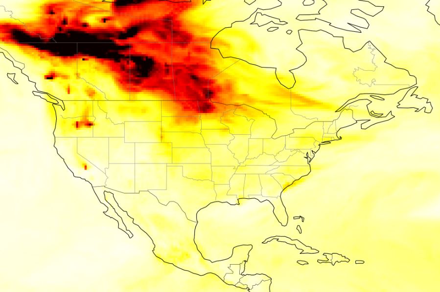
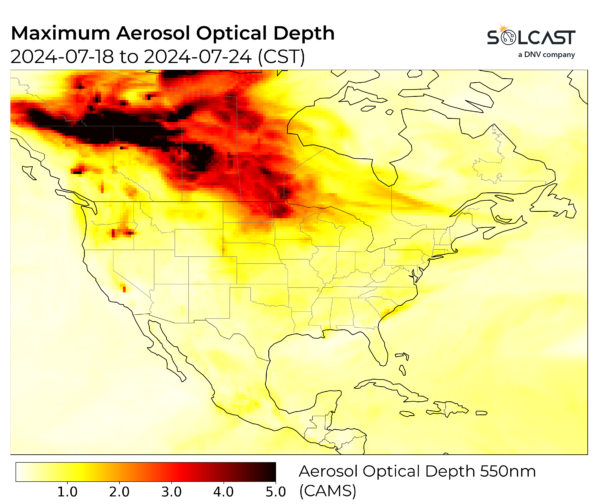
Whilst the fires raged, atmospheric aerosols have blown east and south, across the continent. Aerosols impact irradiance by scattering and absorbing radiation in the atmosphere, and reduce solar generation even on a day with no clouds. Peak ‘aerosol optical depth’, a measure of the impact of aerosols on irradiance, shows where the aerosol impact was strongest, and that smoke impacted all of the continent.
The below analysis of clearsky irradiance (a measure of irradiance before cloud or other weather phenomena) down up to 20% in some regions of Canada close to the fires, shows the large areas impacted as the smoke spreads through the atmosphere. Whilst in a normal month the impact of clouds and weather is much higher than that of aerosols, the intensity of this impact across July is reflected in the clearsky irradiance and the overall GHI.
![]()
In addition to the fires, a strong upper-atmosphere dipole created clear and stable conditions on the West Coast and unstable, cloudy conditions on the East Coast. This led to irradiance levels 10-20% above long-term averages in parts of British Columbia, Washington State, California, Utah, Colorado, Arizona, New Mexico, and Western Texas. While these clear conditions exacerbated the wildfires, prevailing westerly winds prevented the smoke from significantly impacting these states. Conversely, the same atmospheric conditions led to instability on the East Coast, reducing irradiance in the Carolinas, Virginia, and parts of New England. Hurricane Beryl further affected irradiance, casting a large shadow over the Gulf Coast and South-East early in the month.
Solcast produces these figures by tracking clouds and aerosols at 1-2km resolution globally, using satellite data and proprietary AI/ML algorithms. This data is used to drive irradiance models, enabling Solcast to calculate irradiance at high resolution, with typical bias of less than 2%, and also cloud-tracking forecasts. This data is used by more than 300 companies managing over 150GW of solar assets globally.
The views and opinions expressed in this article are the author’s own, and do not necessarily reflect those held by pv magazine.
This content is protected by copyright and may not be reused. If you want to cooperate with us and would like to reuse some of our content, please contact: editors@pv-magazine.com.

By submitting this form you agree to pv magazine using your data for the purposes of publishing your comment.
Your personal data will only be disclosed or otherwise transmitted to third parties for the purposes of spam filtering or if this is necessary for technical maintenance of the website. Any other transfer to third parties will not take place unless this is justified on the basis of applicable data protection regulations or if pv magazine is legally obliged to do so.
You may revoke this consent at any time with effect for the future, in which case your personal data will be deleted immediately. Otherwise, your data will be deleted if pv magazine has processed your request or the purpose of data storage is fulfilled.
Further information on data privacy can be found in our Data Protection Policy.