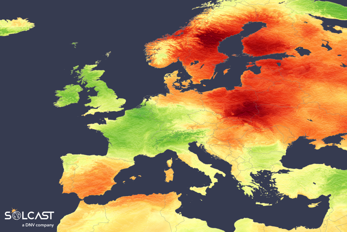
In May, Europe experienced a striking contrast in solar irradiance, shaped by two dominant weather systems. Persistent high pressure over Scandinavia limited normal summer convective cloud and rainfall, leaving Eastern Europe with significantly increased irradiance, while opposing low-pressure systems over Western Europe dragged cloud onshore from the Atlantic and the North Sea. This juxtaposition resulted in a month of starkly divergent solar conditions, according to analysis using the Solcast API.

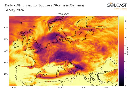
Regions including the UK, Ireland, France, Southern Germany, and Northern Italy experienced irradiance up to 20% below average. This deviation was due to the anomalous low-pressure over Western Europe, which advected moisture from the Atlantic and North Sea onshore. In combination with surface heating from the summer sun, this created an unstable airmass, leading to convective showers and a wetter, cloudier May than usual. This weather pattern has persisted into early June, with Southern Germany experiencing significant flooding and continued cloud cover, limiting solar production in an area with relatively high residential and utility scale solar capacity.
Southwestern Spain and southern Portugal benefited from the shielding effect of the Pyrenees from the low pressure in Western Europe, resulting in irradiance 10% above the May average. Southern Italy was likewise protected by the Alps and saw irradiance around the seasonal norm, as typical summer convection driven by Mediterranean moisture prevailed.
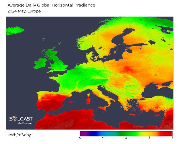
In contrast, wide swathes of Eastern Europe and Scandinavia enjoyed irradiance 20-30% above the long-term average. The high pressure centered over Scandinavia inhibited the formation of convective clouds and rainfall, drawing in a relatively warm and dry continental airmass from Eurasia. This led to warm temperatures and relatively sunny skies. Notably, Finland and Sweden had irradiance up to 30%, which unusually resulted in higher total irradiance than the more southerly UK and France. On the other side of the Baltic Sea, Poland, the Baltic States, and neighboring countries also experienced irradiance up to 30% above the long-term average. However, closer to the Mediterranean, irradiance in Eastern Europe was nearer to typical levels as normal summertime convection took hold.
Solcast produces these figures by tracking clouds and aerosols at 1-2km resolution globally, using satellite data and proprietary AI/ML algorithms. This data is used to drive irradiance models, enabling Solcast to calculate irradiance at high resolution, with typical bias of less than 2%, and also cloud-tracking forecasts. This data is used by more than 300 companies managing over 150GW of solar assets globally.
The views and opinions expressed in this article are the author’s own, and do not necessarily reflect those held by pv magazine.
This content is protected by copyright and may not be reused. If you want to cooperate with us and would like to reuse some of our content, please contact: editors@pv-magazine.com.


By submitting this form you agree to pv magazine using your data for the purposes of publishing your comment.
Your personal data will only be disclosed or otherwise transmitted to third parties for the purposes of spam filtering or if this is necessary for technical maintenance of the website. Any other transfer to third parties will not take place unless this is justified on the basis of applicable data protection regulations or if pv magazine is legally obliged to do so.
You may revoke this consent at any time with effect for the future, in which case your personal data will be deleted immediately. Otherwise, your data will be deleted if pv magazine has processed your request or the purpose of data storage is fulfilled.
Further information on data privacy can be found in our Data Protection Policy.